Week in OSINT #2020-17
Some tips, a reverse image search, a new imagery website and the almost mandatory ‘corona section’
It’s time again for a short update with some nice things that I found last week while browsing the web. I kind of missed checking social media for new tips and links, or maybe I’m slightly going crazy by now? Maybe it’s time to bring in the cavalry soon to help me out with it.
- Keep EXIF Data in WhatsApp
- Aliseeks
- YouTube Workflow
- Aerial Imagery
Tip: Keep EXIF Data in WhatsApp
Sam Dubberley from Amnesty's Crisis Response Team shared a tip last week that can be extremely helpful for journalists. Since WhatsApp and Facebook are wildly used over the world, and especially in Africa, journalists use this often to communicate with people. When receiving images, they are mostly resized and stripped of the EXIF information. That is, until you send it as a document via WhatsApp. Thanks for the tip Sam!
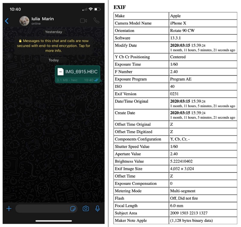
Link: https://citizenevidence.org/2020/04/20/sending-encrypted-photos-while-preserving-metadata/
Site: Aliseeks
Twitter user Blaauw shared a website that I totally forgot about! Aliseeks offers a reverse image search for products, but searches within AliExpress or eBay listings.
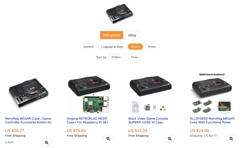
He also shared two extensions for Chrome and Firefox in his tweet but I chose to share two other ones, from the original makers. I usually choose to do so to minimise the chance of breaking extensions when a site changes.
Link: https://www.aliseeks.com/
Firefox: https://addons.mozilla.org/en-US/firefox/addon/aliexpress-search-by-image-ext/?src=search
Tip: YouTube Workflow
Sinwindie created another new workflow for OSINT investigators, this time about YouTube videos. Don’t forget to combine that with my blog about about extracting information from Google accounts, that you can find in this post!
Here's the completed #oSINt workflow showing the major points of #exploitation I look for when #investigating Youtube accounts.
— Sinwindie (@sinwindie) April 25, 2020
Keep in mind, not all accounts will contain all points. pic.twitter.com/KqrUk3xx5u
Link: https://twitter.com/sinwindie/status/1253838272909979650
Site: Aerial Imagery
This weekend I saw a tweet from Obretix where he mentioned the website Soar. I didn’t hear of it before, but I truly hope they will get popular very soon. They offer satellite, aerial and drone imagery and a really nice interface. Don’t expect a lot of hi-res imagery yet, but do expect a few interesting areas in the Middle East, an interface that lets you measure and annotate, and a growing community with access to drones!
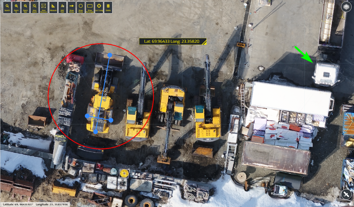
Link: https://soar.earth/

| GeoGuessr
Even though there are some paid subscriptions, it is still possible to play GeoGuessr for free with Mapillary maps. But if you need help recognising blurred license plates, want to know where the most corn fields are in the USA, or even the distribution of olive trees in the world, then grab a snack and go over this extremely long blog post that was shared by Atocat.
Link: https://somerandomstuff1.wordpress.com/2019/02/08/geoguessr-the-top-tips-tricks-and-techniques/
| Movie Locations
BushidoToken wrote a small article on the task of locating the exact spot where Daniel Craig was standing while shooting the movie Skyfall.
Link: https://bushidotoken.blogspot.com/2020/04/osint-investigation-wheres-bond.html
And in case you like to practice your geolocation skills, why not go to one of the many websites that collect that info and help them out, like here:
Link: https://www.itsfilmedthere.com/2012/05/my-top-10-most-wanted-missing-locations.html
| Video Conference Backgrounds
To spice things up a bit when you join a video conferencing, you might want to change your background with chroma key, or with the built-in function of Zoom. And if you are a bit of a geek — like most readers probably — wouldn’t it be cool to experiment with these Star Wars backgrounds?
Link: https://www.starwars.com/news/star-wars-backgrounds
Have a good week and have a good search!