Lake Constance - Geolocation
It has taken well over 7 years before this geolocation challenge was resolved, and I have spent countless hours on trying to find this years ago. Sadly enough, work and other priorities had taken over my life, so the last three years I didn't have time to look at it at all. Until recently, when I managed to find the location of this exact spot, but it wasn't in the usual way.
The original Tweet
Bask in 2017 the Twitter user @CountryTec sent out a tweet, asking for help on locating a specific image from the 50's. This is the original tweet:

The tweet translates to:
I have this photo with my parents taken around the 50's. Does anybody know where this is? Please #RT
One of the first questions that was asked, was what could be written on the monument, and @CountryTec already had a look at that, and with the help of some other people, the deduced it said something along the lines of:
"... SCHWEIZ IN DANKBARER ERINNERUNG AN DIE EISERNE ZEIT ..."
Or, translated: "... Switzerland in remembrance of the iron age ..."
The German term "Eiserne Zeit" is usually for the thirty years' war, that lasted from 1618 to 1648, but it was uncertain whether this monument was that old. People also hinted that in the middle of the monument, on both sides of the inlay, there were the numbers 14 and 18, which may hint towards the first world war.
In July 2018, @CountryTec shared it again, where it received some attention once more. This time, the Twitter account @Quiztime was tagged, after which the Quiztime crew received this challenge. This was the time I saw it, and some great work had been done so far already! The information that was known by then was:
- Taken somewhere around the mid-50's
- Most part of the text was known
- Most probably around Lake Constance
- Might be around Arbon, Seepark Rorschach or Lindau
Looking back at it now, this may have been enough to actually solve it. But it turned out, there was a problem. Spoiler alert, the monument was removed!
How it Started
Looking at most of the information that was available, I tried to have a stab at it with the @Quiztime crew, working closely together with mainly Fiete Stegers []. It seemed a somewhat straightforward quest, and there are certain ideas on what might help geolocate this, like:
- General reverse image search
- Use AI to colour the image, for aid in searching
- Search, in German, for monuments
- Go over public records and local websites
After spending some time doing that, I found that nothing came up. Google, Bing and Yandex showed some monuments that looked similar, but there were no matches to be found. Me and a few people went over some websites, databases, social media, but without any results.
Looking at Shadows
At a certain point, I wanted to know what direction we might be looking, since it might help in finding, or excluding, certain locations. For that, I made some assumptions and tried to measure the shadow that was visible in the image. The first assumption was a rough estimate of the height of the man, and the second was a rough estimate of how long the shadow might be. The third assumption was the idea that this photo was taken in the summer. I based that on the fact that the shadows looked sharp, due to a bright sun, and the way the people were dressed.
All combined, I had the following pieces of information in mind:
- Somewhere in Switzerland, near Lake Constance
- Looking at the background, we are facing a lake
- Somewhere in summer time
- The height of the person around 1.75m
- Length of the shadow was estimated around 80cm

Going over to one of my favourite tools for shadow calculations, I opened up SunCalc. I went over several dates, and found that August and September were throwing shadows that were too long, making it impossible to find a match. Going back to July, I was able to have the sun high enough in the sky that a shadow of about 80cm or so was possible. And it turned out that the sun would have been roughly south. This could be southwest, or southeast, but with all the assumptions made, it was impossible to narrow it down any further.

Since there had been an idea the photo might have been taken around the area of Arbon, Lindau or Seepark Rorschach, which are all south of Lake Constance, this meant people were on the right track.
The Breakthrough
More than six years after I started this quest, where I was not constantly searching, but once every couple of months I would revisit this and look for a new information, it was still unsolved. That was until on November 28, 2024, I went back to the challenge and looked at all the comments to see whether there was any new information. And there certainly was!

Someone who had been looking at the request managed to find some old postcards on a Swiss website, giving an extra hint towards the exact municipality we were looking for: Horn. And there wasn't just a single postcard from Horn that showed this location, but I managed to find 4 in total.

According to the Wikipedia page, Horn lies in the district of Arbon, which was mentioned earlier too. Looking back now, and knowing all the information that was available back then, I am certain we could have solved this well over six years earlier. But having other priorities in life, these things sometimes move to the bottom of the stack, and when you see new information, like Phaedrus' [] his tweet with the postcard, it relights your interest once more. And this time, we needed to finish it all the way.
Old Maps and Photos
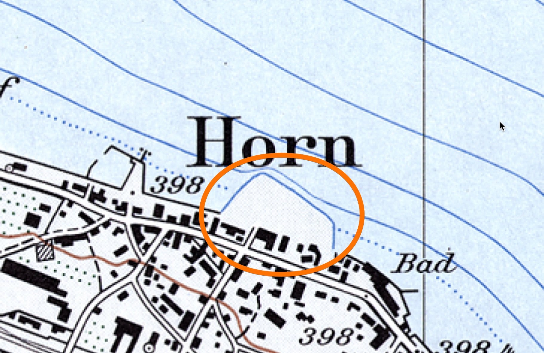
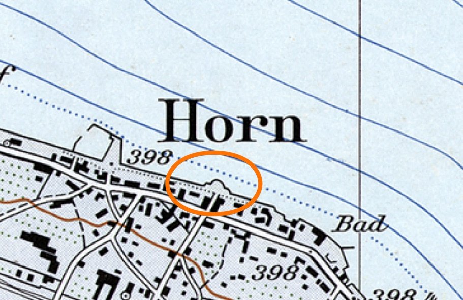
To find out where the monument could have been, I had a look at older maps from the area. Using the historical maps from the Federal Office of Topography Swisstopo, I compared the map of 1960 to the one of a later date, like 1975. And there was an interesting change, because somewhere around the area where I expected the photo to have been taken, the whole area changed. Instead if a small bulge, a large part of land has been added. You can see the comparison below, but sadly enough it doesn't seem to work on a mobile phone.
 1975
1975
 1960
1960
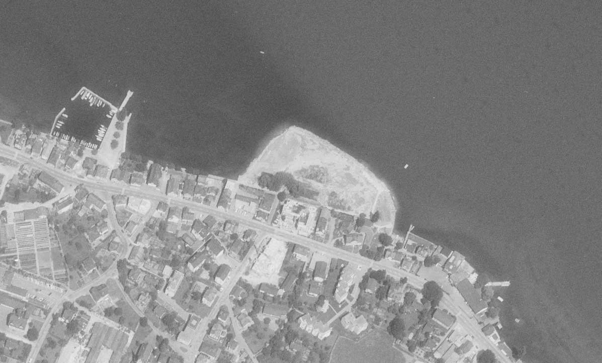
On the website of the Swisstopo office, there is also the option to dive into historical aerial photos. And after going over about 10 or so different images, I chose to show the location as it was in 1935, and in 1972. This clearly shows not just the scale of what has been done to the area, but the image in 1935 also shows the water feature near some trees.
 1972
1972
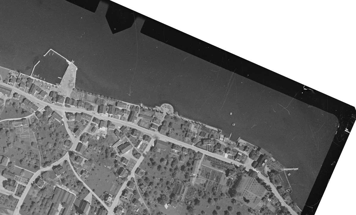 1935
1935
Here is another detailed aerial shot, taken in June 1945, also taken from the website of Swisstopo. Zoomed in, it clearly shows a half circle, a line of trees, and something that resembles a water feature in the center.

On the website of Wikimedia, Fiete Stegers [] found an aerial shot of Horn, made by Werner Friedli in May 1949. After downloading the original image, and zooming in onto the location where the water feature must have been, we can clearly spot the rough outline of the center part of it.

Verification Stage
Since we now had a very strong lead this might be the correct location, and it seemed to match with old maps and aerial photos, it was time to go back and look at the postcards more closely. It was time to go over to Google Earth Pro, GoogleMaps, PhotoShop, and try to line everything up nicely. Measuring the ratio of the distance between the churches or towers that are visible, wasn't a perfect match with the old photographs. But the shape of the churches A (Kirche St. Martin) and C (Pfarrkirche St. Jakobus) do match the general shape that can be seen in the postcard. The only one that is slightly more difficult to see, is church B (Evangelische Kirche Arbon), but given the fact that we are working with digital versions of very old postcards from decades ago, it was the best I could do.

Time to find out more about what happened in this area back then.
Diving into History
Now that we were fairly certain the location is correct, and we even find a part of the landscape changed, we need to find out what happened to the monument. And for that I dove into the state archive of Thurgau, searching for the term I learned while looking into this topic: "Quaianlage", or lakefront. In the archive I was able to find another postcard, with some more information about this monument (in German). The text explains that it was a water feature created by Louis Wethli (1867-1940) and was donated by a German merchant called Alfred Heinrich Klinkmann (1871-1943).
Alfred worked in Milan until the first world war, and chose to move to Horn during this time. Out of gratitude for the hospitality, he commissioned a new water feature, that has been described as a "bench protection". He turned to the Zurich sculptor Louis Wethli, who built it between 1927 and 1928. When in 1969 the lakefront was redesigned, it was removed completely, and only returned on the so called "Festplatz am See" in 1997.
Going over Google Maps and StreetView, we don't see anything that looks like the monument as we have been seeing on the postcards though. But one thing stood out, right on the edge of the "Festplatz am See", a stone feature (Google Maps)

It is very hard to make out, so it is time to have a better look at photos taken in the nearby area. And it doesn't take long before we find an image by Antoine Meyer. In that image, we can see details of the carvings, and comparing them side by side shows elements that absolutely match with the original from one of the postcards. The female figure is mostly hidden in the shadows, and no PhotoShop magic will be abel to enhance that. But the rough shape of her arms are still visible, and looking at the posture of the child on the right, it all matches nicely.

And when we load the image in PhotoShop, and look at the text on the plaque, we are able to recover most of the text, that was characteristic of the original monument:
"DER GASTFREUNDLICHEN SCHWEIZ IN DANKBARER ERINNERUNG AN DIE EISERNE ZEIT DES WELTKRIEGES"
Underneath there seems to be some more text, but I wasn't able to fully reconstruct the full sentence. But after a tip from Louise [], who contacted me by email, the most probably option is the following line:
"1914 - 18 VON EINEM GÖNNER DER GEMEINDE HORN"
Loosely translated, it reads:
"The hospitable Switzerland in grateful remembrance of the iron age of the world war. 1914-1918 by a patron of the community of Horn"

Conclusion
After well over 7 years after the original question was posted online, and thanks to the help I received from Fiete Stegers [] and the unsung hero over on X, called Phaedrus [], we were able to finish this chapter. By a complete overhaul of the landscape, it turned out it was rather difficult to find the location, yet not impossible. Due to this challenge, I found much more useful resources, found out there are way more historical aerial photos than I knew, and combined all sorts of techniques to verify everything.
And after I posted my last message about it on X at 10:30 PM, it took some random account less than two hours to claim he or she found it, via a post on Reddit. Jumping in on the bandwagon, replying to a different thread about this photo, trying to take all the credits. If there is one person that deserves credits, it is Phaedrus [], who gave everyone a nudge in the right direction after several years, by finding the postcards.
